How to hike Rooster's Ridge (Kai Kung Leng)
- Exploring Dogs
- Jan 4, 2023
- 2 min read

Updated: Jan 9, 2023
Rooster's Ridge, also known as Kai Kung Leng (雞公嶺 ), is a breath-taking, point-to-point walk with views over Yuen Long and Shenzhen. Although a moderately challenging walk, this trail is quite popular amongst hikers, trail runner and mountain bikes riders. Just be sure to attempt this walk in cooler months as the entire trail is completely exposed, and could be fatal for dogs on a hot day!
Overview
Distance: 6.6 kilometres approx. Difficulty: Intermediate - Advanced Total ascent: 572 metres approx. Total time: 3-4 hours approx.
We suggest starting from Fan Kam Road and ending in Kam Tin, as you can then treat yourself to a Thai feast at Thai Cow! It would also be easier for you to catch a taxi or Uber home from Kam Tin, making heading home one less thing to worry about.
The Start


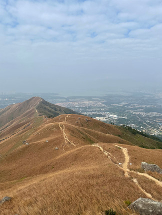


The starting point of this walk passes a village house, so just be careful of village dogs at the beginning of this trail. You'll start off by climbing up some steps through some trees, before coming out to the exposed, dirt trail, where the trail really starts to become tricky. The first climb is the toughest, as you are required to tackle a well-worn path up to the biggest of the three peaks, first, standing at 585m! Be sure you're wearing your best hiking shoes as the steep climbs are challenging enough without the powdery and loose gravel.
The Hike


Although you're following a well-trodden dirt path, and the climbs over the three peaks can be physically challenging, the trail itself is pretty easy to follow, requiring very little map-reading allowing you to "switch off" and simply enjoy your surroundings.
The plus-side is you're treated to spectacular 360 views of the New Territories, with Tai Mo Shan in the distance, which is unlike any other in Hong Kong.
After you have tackled the ridge, you'll come out to a cluster of rocks known as the Guijiao Stone Ridge, which offers a great spot to stop for drinks, and take in the views.
Once you come out to a Transmitting Station, this signals that you're near the end of the walk, and you'll start to descend some steep steps towards Fung Kat Heung Road, with glimpses of the marshlands and Fairview Park in the distance.


Comments